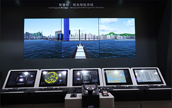
Smart Bridge Integrated Navigation System (HLD-INS 600) is mainly composed of multi-functional workstations with isolated redundant network connections. The number of workstations can be configured according to the actual needs of users to achieve the integration of information and functions. Each workstation can provide task functions such as route planning, navigation monitoring, collision avoidance, track control, navigation status and data display, and central alarm management. The system seamlessly integrates various navigation safety-related data such as position, heading, speed and surrounding targets. It has a consistent user interface design, which is convenient for crew members to use. It can effectively reduce the burden on crew members and complete navigation work more efficiently.
Smart Bridge Integrated Navigation System (HLD-INS 600) is mainly composed of multi-functional workstations with isolated redundant network connections. The number of workstations can be configured according to the actual needs of users to achieve the integration of information and functions. Each workstation can provide task functions such as route planning, navigation monitoring, collision avoidance, track control, navigation status and data display, and central alarm management. The system seamlessly integrates various navigation safety-related data such as position, heading, speed and surrounding targets. It has a consistent user interface design, which is convenient for crew members to use. It can effectively reduce the burden on crew members and complete navigation work more efficiently.
Smart Bridge Integrated Navigation System (HLD-INS 600) fully meets IMO specification MSC.252(83) and international standard IEC 61924-2. And passed CCS and DNV-GL type certification.
Feature Highlights:
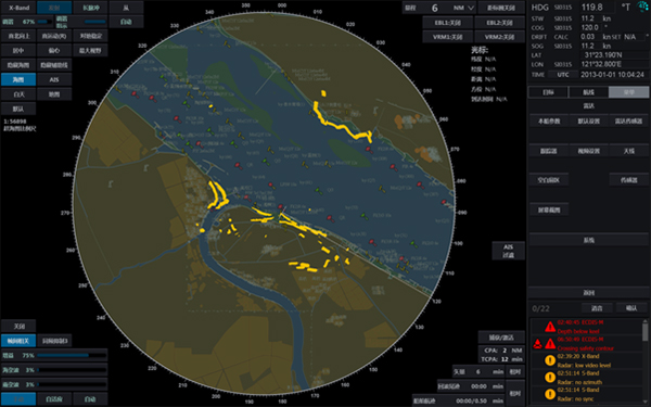
HLD-RADAR 900/900C series products have passed CCS\DNV-GL radar type certification and support standards that comply with the IMO/SOLAS convention and the latest radar system specification IEC 62388-2013.
HLD-RADAR 900/900C series products have passed CCS\DNV-GL radar type certification and support standards that comply with the IMO/SOLAS convention and the latest radar system specification IEC 62388-2013.
Feature Highlights:
Independent radar chart, can be used as backup ECDIS
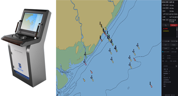
HLD-ECDIS600 is an electronic chart display and information system independently developed by Highlander. The system software has been verified by actual ship use and is easy to use, stable and reliable. The product supports Chinese/English switching, online chart data update, radar image overlay, weather overlay, route generation and optimization, track control and other functions.
HLD-ECDIS600 is an electronic chart display and information system independently developed by Highlander. The system software has been verified by actual ship use and is easy to use, stable and reliable. The product supports Chinese/English switching, online chart data update, radar image overlay, weather overlay, route generation and optimization, track control and other functions.
This product is specially designed for "paperless navigation" and meets the requirements of IMO specifications and the latest IEC standards. It has passed the EC/MED (B+D) type approval of China Classification Society CCS and Det Norske Veritas DNV-GL.
Feature Highlights:
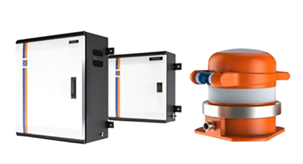
Highlander's new generation of navigation data recorders (HLD-VDR600/SVDR600) combines the experience of using about 8,000 ships and adopts a variety of unique technical solutions. The product is stable and reliable, with flexible configuration, which can meet various customer needs.
HLD-VDR600/SVDR600 can realize the "+Internet" function and provide "Hi-Cloud" ship remote information service. Users can easily understand the status of the ship through the client terminal or mobile terminal iPad, manage the ship efficiently, and realize remote diagnosis and maintenance of the equipment.
HLD—VDR600/SVDR600 fully complies with the requirements of the latest standards such as IMO A.861 (20), MSC.333 (90), IEC61996-1:2013; MSC.163 (78), IEC61996-2 and IEC60945, and has obtained DNV- Type certification from classification societies such as GL, RS, CCS, etc.
Feature Highlights: